Satellite Textscapes and Reframing the Multispectral Gaze
Richard A. Carter
This visual essay documents the author’s developing artistic project Orbital Reveries. This project compiles terrestrial satellite imagery using data from the Landsat Earth observation programme, and then sequences it through an algorithmic matrix to compose generative visual ‘textscapes’. In parsing technoscientific data into experimental artworks, this project follows the conjectures of a number of theorists concerning the potential for speculative modes of sensory practice—going beyond ‘the utensil-problem space, where environmental sensors facilitate increasingly regimented and automated ways of life’, to ‘consider how environmental computational practices open into experimentation, expanded experiences, and speculative adventures’ (Gabrys 270). This essay will discuss the project’s motivating contexts, before detailing its formal and technical attributes, and then relating these back to a number of critical themes—especially the possibilities of expressing the collaborative entanglements between different sensing and interpreting agencies—both human and more-than-human—that make it possible to characterise fundamental transformations in climate, ecology, and culture across the contemporary world. All images in this essay have been compiled by the author using data courtesy of USGS.
Landsat
In September 2021, under the joint aegis of NASA and the United States Geological Survey (USGS), an Earth observation satellite, designated Landsat 9, will be lofted into a sun-synchronous orbit at an altitude of 705km. Equipped with two passive sensors for measuring terrestrial signals in the visible, near infrared, and shortwave-infrared bands, Landsat 9 will support and ultimately supersede the work of its older sibling, Landsat 8, which was orbited in February 2013 (COSPAR ID: 2013-008A, SATCAT No: 39084). In so doing, Landsat 9 shall uphold what is presently, at the time of writing, the longest running civilian programme, by any nation, for collecting satellite imagery of the Earth’s surface.
The political, scientific, and technical antecedents of Landsat are manifold, although an evocative point of origin can be observed in the rush of human spaceflight programmes of the 1960s. In generating an incidental body of rich, detailed imagery of the whole Earth from an orbital vantage, these programmes provided a vibrant catalyst for examining whether systematic monitoring of its surface features might be scientifically fruitful—building on the highly successful (although still relatively nascent) deployments of metrological satellites. Efforts at developing tools and frameworks for this end had commenced already as early as February 1965, with the NASA Earth Resources Survey programme (Ezell). Eventually, following several conceptual studies and some measure of political discussion, NASA signed the approval documents for the Earth Resources Technology Satellite (ERTS) programme, on January 7th 1969, which included an economic benefits study, a spacecraft systems design study, and, crucially, initiating long lead-time sensor and instrument development.
A key component of the latter began on August 16th 1969, when NASA awarded the Hughes Aircraft Company a contract to design the Multispectral Scanner System (MSS) (Ezell). The MSS would be an experimental sensor that gathered imagery of the Earth’s surface across four distinct spectral bands, spanning from the visible through to the near-infrared. The chief value of this instrument would be in gathering concurrent, accurately comparable imagery that could utilise the feature extraction capabilities afforded by different wavelengths. A few months later, in April 1970, Hughes was awarded a follow-up contract to prototype and test the MSS that would be deployed aboard the ERTS demonstrators, which were to be built around the bus architecture of the Nimbus 4 metrological satellite (Ezell).
On July 23rd 1972, the first demonstrator satellite, ERTS-A, was orbited successfully. Designed only to operate for a few months until early 1973, ERTS-A ultimately lasted until January 1978, during which time it was renamed ‘Landsat 1’ in 1975. Over the course of its five and half years of operation, the quality and utility of the imagery it supplied was immediately and widely apparent. Mack provides a succinct summary of its many achievements:
In technical terms the project proved almost completely successful. The satellite functioned as planned and delivered the promised data, which provided information of value to scientists studying agriculture, geology, land use, and in many other fields. The sensor that had seemed more of a risk during development, the Multispectral Scanner, proved particularly valuable because the data from different spectral bands (in effect different colors) could be compared accurately. Satellite data proved most dramatically beneficial to developing countries; in many cases Landsat images provided the first adequate maps of remote regions. Scientists found much useful information, however, even for well mapped areas. Landsat data could indeed provide information on everything from urban growth to ice cover in shipping lanes to the health of vegetation (Mack).
Managing the Earth
In July 2022, the Landsat programme will celebrate its fiftieth anniversary, but its deep embeddedness within strategies of terrestrial resource management has remained largely unchanged since the launch of ERTS-A / Landsat 1. On a European Space Agency (ESA) website providing an overview of its upcoming mission, Landsat 9 is described as:
[Extending] our ability to measure changes on the global land surface at a scale where we can separate human and natural causes of change. When land use and resource availability issues arise, Landsat 9 will help decision makers make informed management decisions. Landsat 9 will thus contribute a critical component to the international strategy for monitoring the health and state of the Earth (Kramer).
In this passage, the Earth is characterised as an object of knowledge and of control, one to be carefully shepherded and managed in relation to human requirements—and, implicitly, the political imperatives of those nations involved in sponsoring and maintaining Landsat hardware and data infrastructure. Moreover, despite multiple surrounding references to ecological and climactic monitoring as a core benefit of the Landsat programme, the above passage maintains a divisibility between human and more-than-human phenomena and processes, with the former carrying the greatest implied agency (and value) over the latter. Coming at a time of keen scientific, cultural, and critical debate around the proposed epochal threshold of the ‘Anthropocene’, and its heralding of an apocalyptic entanglement between human activity and Earthly ecologies, this sense of division speaks to the more troubling discourses that have both enabled and sustained the Landsat programme over the past half-century.
As far back as 1997, Karen Litfin noted ‘the remote sensing project functions simultaneously as symptom, expression, and reinforcement of modernity’s dream of knowledge as power’, and that ‘the miniaturization of the earth made possible by satellite photography appeals to the managerial impulse’ (39), in depicting a delimited, purely geophysical domain that can be readily enclosed and controlled from above, as opposed to a planetary milieu with billions of peoples, multitudinous cultures, and intricate ecological dynamics. Litfin went on to observe:
Neither the science nor the technology of Earth remote sensing is neutral ... EOS [Earth Observing Systems] technology, at least as presently constituted, seems to reinforce the drive to industrialization and the interrogatory approach to nature that lie at the heart of modernity. The global view that it purports to provide may become a totalizing perspective that omits human agency and substitutes the vantage point of a technical elite for the collective experiences of the diversity of human beings. EOS technology, like other photographic technologies, is a voyeuristic endeavor that maximizes the distance between subject and object-in this case, between the observing human and Earth’s dynamic processes. Finally, the language of planetary management that pervades discussions of EOS suggests that the disciplinary power inherent in the managerial impulse is at the heart of the remote sensing project. (Litfin 40)
There are myriad intersecting discourses, problematics, and debates identified by Litfin here, all of which possess a deep history, and these have since only grown in relevance alongside the data-driven episteme they critique. Although this discussion will not be attempting a thorough critical excavation of the Landsat programme, it will return later to some of the above points by way of characterising my artistic project Orbital Reveries, which enacts a creative response to the critiques made by Litfin and other scholars subsequently.
Creative Contexts
Orbital Reveries represents an outgrowth of an earlier zine project entitled The Landsat Reverie, which was a contribution to the zinesindarktimes project by artist and writer Joanna Walsh. Published in the Spring of 2020, The Landsat Reverie was a visual poetic meditation on the historic origins of the Landsat programme, and it prototyped several key ideas which later enabled Orbital Reveries. Both projects can be summarised as repurposing Landsat imagery to produce hybrid compositions that seek to connect these abstracted ‘data products’ with their enabling languages and contexts, and so reflecting creatively on the purposes and meanings of satellite imagery within the contemporary environment. As will be detailed shortly, Orbital Reveries involves parsing satellite scenes through multiple algorithms that transform their terrain signatures into generative ‘textscapes’. These take the form of diptychs featuring diagrammatic structures and enigmatic constellations of words, with the latter drawn from a variety of sources relating to the historic, discursive, and scientific contexts of Earth observing systems.
My aim in developing Orbital Reveries, as a project that is simultaneously creative and reflective in scope, is not the pretence of establishing a new front in the critical assessment of satellite infrastructure, but to explore, tentatively, a more experimental, speculative vector: how practices of remote sensing might be re-oriented in-light of criticisms around their role in characterising the Earthly environment. Here, Orbital Reveries is being conducted in the spirit of conjectures by Gabrys concerning the potential for creating new, speculative modes of sensory practice—going beyond ‘the utensil-problem space, where environmental sensors facilitate increasingly regimented and automated ways of life’, to ‘consider how environmental computational practices open into experimentation, expanded experiences, and speculative adventures’ (Program Earth 270). Elsewhere, Gabrys asks whether it might be possible ‘not to remake the pretensions of globality and globalization through planetary media projects, but rather begin to unsettle figures of totality and regulation in order to attend to the incommensurate, the unjust, and the yet to be recognized’ (‘Becoming Planetary’). As expressed by Litfin’s critiques, it is the visualised, globalised, and globalising episteme behind Earth observing systems that render contemporary environmental challenges apprehensible and resolvable purely through the privileged techno-logics of quantification and abstraction—further embedding the very challenges these paradigms helped to precipitate, and marginalising a multitude of knowledge-making practices beyond the scientific, including those intrinsic to different cultures around the world, and which are crucial for grappling with life on a profoundly damaged planet.
One may cite here Schuppli’s documentary and essay ‘Can the Sun Lie?’ as offering a pointed encapsulation of these aspects, in contrasting scientific accounts of climate change with the storytelling traditions of northern Inuit communities. Intimately attuned to the materialities of their environment, Inuit observers began recounting distortions in solar and stellar positioning due to temperature-driven atmospheric refractions—a manifestation of how climate change is transforming ‘the surfaces of the earth into a vast array of quasi-photographic plates, each of which is recording the atmospheric chemistry of terrestrial change differently’ (60). Some Inuit observers characterised these distortions as being due to planetary axial-tilt, as the best available analogy for expressing their changing world, but this lead subsequently to their experiences and accounts being relegated as incommensurate with the standard models of Western climate science—as something to be consciously marginalised, lest it discredit the latter (63).
Such critiques highlight a need for expanded conceptions of sensory activities and their expression, offering a fuller account of a world that is transforming in ways beyond the prehension of digital sensors and data alone—as manifested in practices, lives, and cultures outside of Western technoscience. Nonetheless, the question that motivated my own reading of Litfin’s and Gabrys’ work concerned whether digital systems might yet still contribute to processes of their own reframing. That is, to move beyond any deterministic accounts of their utility, which would relegate them only as enemies of the Earth, and to explore instead how they can be re-situated as part of a spectrum of sensing and sense-making practices, able to enter into unconventional, exploratory dialogues with other modes of knowledge-making and expression, and so crystallise the ‘expanded experiences, and speculative adventures’ made possible through different kinds of environmental computational practices. Stated plainly, I wanted to explore what other manifestations of satellite sensing might be rendered, and what kinds of processes and artefactual outcomes could arise, if tasked with responding concretely to the observations and critiques made above. Parikka has characterised not dissimilar undertakings as modes of ‘speculative media archaeology’ (27), which might be understood in relation to Agre’s ‘critical technical practices’, wherein reflexive medial questions form a core concern not only for the production of conventional scholarship, but for other kinds of artefactual production and aesthetic provocation, with the goal of critiquing assumptions encoded within technology itself and its communities, as well as testing concretely different hypotheses and principles through which these might be reworked.
For their part, Gabrys and Litfin both forward speculative, citizen-led deployments of sensory technologies and practices as a useful vector to pursue here—establishing new figurations and knowledge-making collectives that evade the vertical, linear structuring of established disciplines. A subset of these citizen-science engagements might be found in the domain of artistic practice, as a means of concurrently pursuing enacted critique alongside speculative exploration. There is already a long history of artistic projects involving satellites, their data products, and associated infrastructures, for examining reflexively their orbital outlooks, and so de-coupling their physical remoteness from a sense of their invisibility and inaccessibility. Heidi Neilson is an extensive practitioner here, with a range of projects visualising the data-streams of Earth observation satellites, or drawing attention to their status as physical artefacts. Nielson’s installations Go GOES Radiotelescope (2017) and Here GOES Radiotelescope (2020) feature large-scale dish antennae that both point at, and receive, information from the geostationary weather satellite position GOES-EAST (occupied currently by GOES-16, COSPAR ID: 2016-071A, SATCAT No: 41866). These installations are arranged in such a way that a viewer must look through an eyepiece aligned with the satellite itself, like a telescope, in order to see the images it downlinks from its own perspective. The effect here is to highlight the technical materiality of the ‘God’s eye view’ provided by this combined apparatus, and thus create an exchange that binds the vertiginous remoteness of GOES-16 with the Earth below, rendering it prehensible and tractable to a non-specialist observer.
Sasha Engelmann and Sophie Dyer also engage weather satellites as part of their recent ongoing project Open-weather (2020—), probing the ‘noisy relationships between bodies, atmospheres and weather systems through experiments in amateur radio, open data and feminist tactics of sensing and séance’. Specifically, the project has generated a series of practical guides, critical frameworks, and public workshops that encourage participants to receive and process their own weather satellite data using free, open-source, and/or inexpensive hardware and software, while also exploring questions around ‘who or what gains power from satellite imagery, radio technology and meteorological data?’ The end result is not so much a set of discrete artworks as a communal body reflecting on the critical, poetic, and political entanglements inaugurated by satellite sensing.
Trevor Paglen’s The Last Pictures (2012) and Orbital Reflector (2019) represent two instances of artworks that have employed actual satellite hardware to create spaceborne installations. The former involved engraving a small disc with a hundred photographs of Earthly life and attaching it to a geostationary communications satellite, EchoStar XIV (COSPAR ID: 2012-065A, SATCAT No: 39008). Still functioning at the time of writing, EchoStar XVI will be lofted eventually into a designated ‘graveyard’ orbit at the end of its useful life, where, if undisturbed, it will remain for billions of years. Orbital Reflector was a much grander enterprise: a dedicated cube satellite equipped with a deployable reflective structure, designed to create a highly visible artefact in the night-sky for a short period. Orbital Reflector (COSPAR ID: 2018-099P, SATCAT No: 43771) failed not long after its launch in December 2018, owing to an economic shutdown in the communications centres required for its successful deployment—a straightforward encapsulation of the attachments between orbital systems and terrestrial infrastructures, personnel, and politics. Consequently, the remaining satellite body has been left stranded in orbit for potentially many years, as opposed to the intended plan of weeks, and so forming ‘space junk’ that must be negotiated by future missions. Both of these artworks, whether deemed successful or otherwise, provide suggestive points of reflection on the potential usage of outer space for activities beyond military or commercial imperatives, as well as highlighting the status of satellite infrastructures as effectively permanent additions to the orbital environment: offering a striking sense of the full vertical scale of the Anthropocene, as reaching far beyond the terrestrial and atmospheric domains.
All these projects illustrate the immediate contexts in which Orbital Reveries manifests, as concurrently creative and critical enquiries into the role and significance of satellite infrastructures within the contemporary environment. Moreover, they are suggestive of what forms these may yet take in the future, opening out into the kinds of adventurous modes which denature established discourses and enact alternative vectors of thought and practice. It is in this register especially that Orbital Reveries operates, concerning itself with how the modes of representation associated with satellite imagery—growing out of efforts at realising a sense of universality, globality, and control—might yet contribute to their own reworking—to explore how their vertiginous gaze may be turned inwards, acknowledging their origins and impacts, while concurrently reaching for new possibilities beyond them. The formal and technical configuration of Orbital Reveries therefore represents a specific response to key discourses shaping the role, utility, and overall scientific and cultural reception of satellite imagery—prototyping a different expression of what it might go on to signify, particularly in terms of reaching beyond conceptions of the kind Litfin observed originally: of certainty, objectivity, transparency, and control.
Formal and Technical Attributes
There is still much to unpack and qualify at this point, but before discussing further the contexts, aspirations, and implications of the Orbital Reveries project, it is worth pausing to explain more concretely its formal and technical attributes. For the benefit of future readers, it should be noted that at the time of writing this project is still undergoing some measure of development, as befits its experimental premise, and thus what is outlined below represents its configuration as of summer 2021. Moreover, the images presented in this essay have been produced specially to illustrate the project’s latest iteration, and these differ stylistically from earlier versions that have been published elsewhere online and in-print—these being reliant on simpler, prototype implementations of the systems and processes described below.
The initial phase of the creative process involves gathering Landsat data from the USGS ‘Earth Explorer’, an online tool for identifying and collating image data from almost every current and legacy remote sensing platform employed by various U.S. agencies, including declassified military outputs. It is important to note that the images available through this interface are not the precompiled, natural-colour scenes found within popular media reporting. Instead, they exist as a series of data files that are associated with the sensory payloads carried by different satellite platforms. In the case of Landsat 8, eleven different imaging bands can be accessed for a given terrestrial scene, with each covering specific areas of the electromagnetic spectrum—taking advantage of the spectral properties exhibited by different materials and processes, and thus serving better to isolate or reveal them than the narrow bandwidth of human colour vision. The files relating to each band can be compiled into varied combinations, and so generating either natural or false-colour composites, depending on the kinds of information sought (Loyd). For Landsat, these combinations are often referred to using a three-figure index, indicating which spectral band is allocated to the Red, Green, or Blue (RGB) channels of the final composite image, and thus actualising, for human eyes, the different attributes of a scene, such as vegetation levels (i.e. 543), land and water features (i.e. 564), anthropogenic artefacts and activities (i.e. 762 and 652), as well as natural colour emulations (i.e. 432) (Peters).
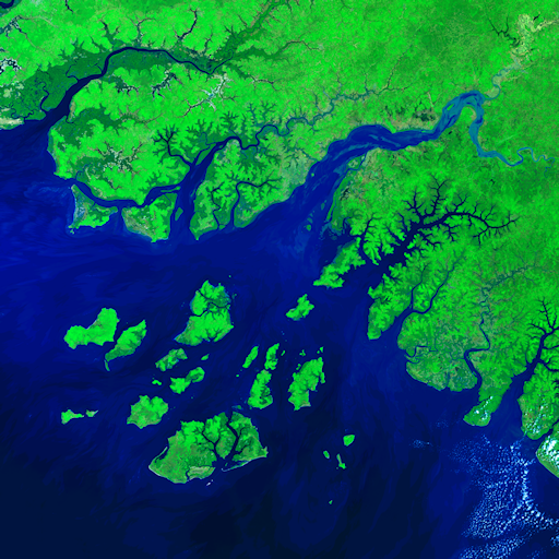
In this window, the same scene of Guinea-Bissau is compiled into three distinct multispectral RGB composites. From Left to Right: 432 (natural colour), 543 (colour infrared), and 652 (false colour). Compiled by the author, using data courtesy of USGS.
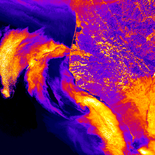
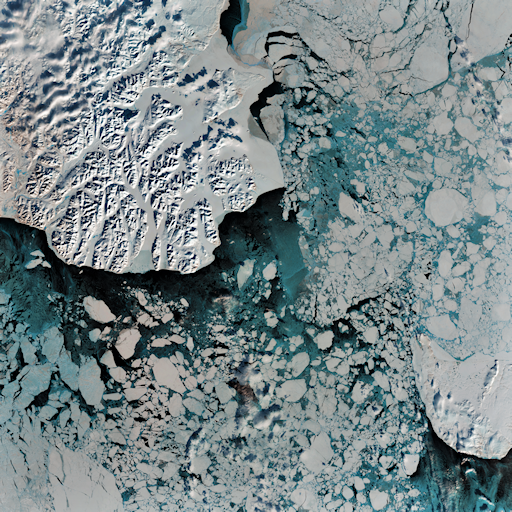
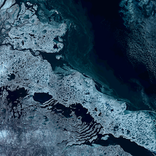
For Orbital Reveries, the source data has been compiled from across the different sensory bands supported by Landsat 8, turning these into RGB composites using a scientific imaging toolkit called ImageJ. Thus far, a relatively open criteria has governed the geographical scenes gathered for such processing, either being weighted towards landscapes evidencing ecological stress and anthropogenic harm (such as the 2020 California Wildfires, and melting glacial regions), or areas that are especially vulnerable to such, or that represent instead prominent markers of ‘satellite geography’—structures on the Earth’s surface, both geological and anthropogenic, that are appreciable only from a significant altitude (and in the case of the latter, may be designed specifically for this end, such as with Dubai’s trio of Palm Islands).
A similar openness has prevailed when selecting which sensory bands are used to compile the final scenes, being governed by whether a particular band combination is suited for highlighting extant features of interest, such as fires, ices, or vegetation, or, instead, yield notably striking hues and textures. This more playful attitude, incidentally, echoes that behind the NASA-USGS ‘Earth as Art’ compendiums, which curate and showcase Landsat scenes that are radiantly colourful or evocative of miniature vistas in their own right, as made possible by applying different band combinations and colour balance levels for aesthetic effect (‘Earth as Art’).
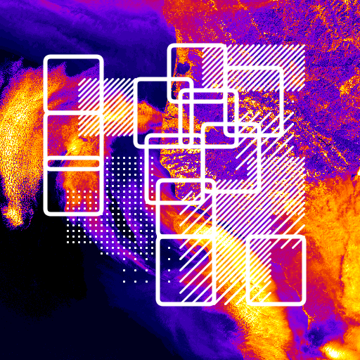
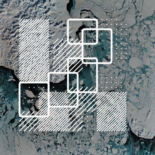
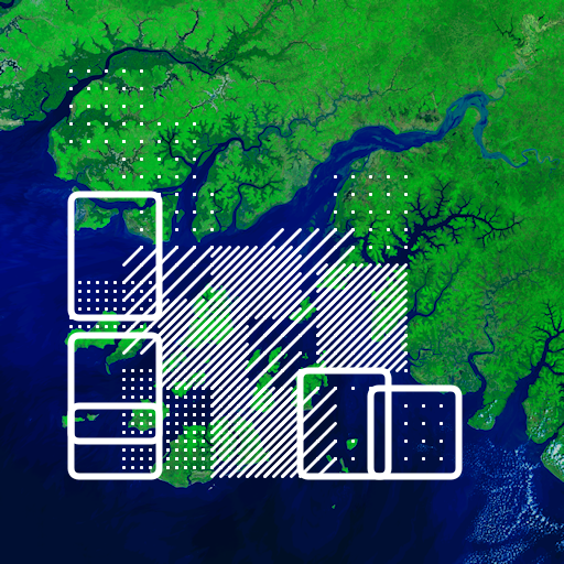
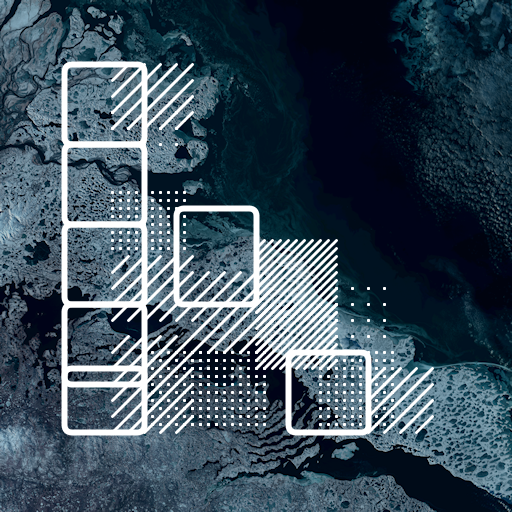
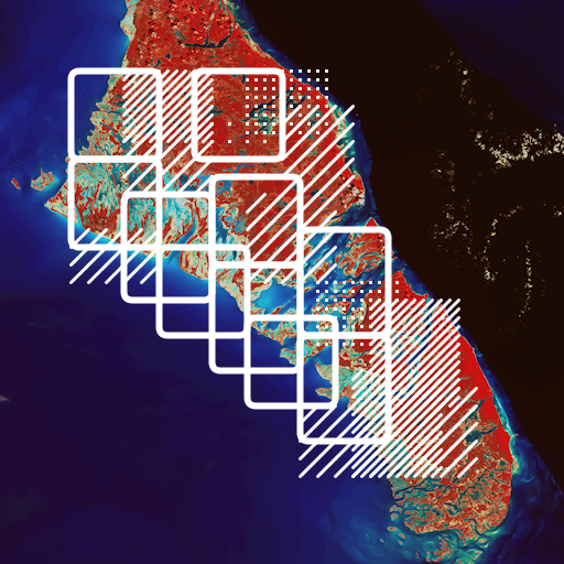
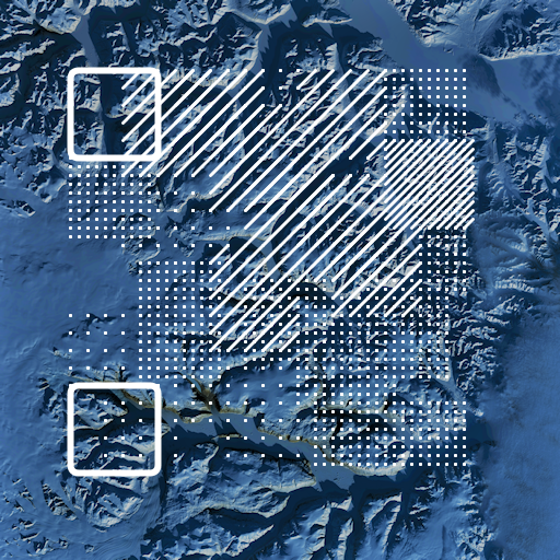
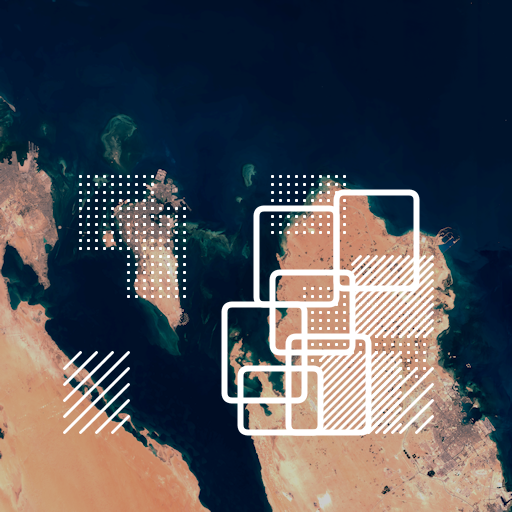
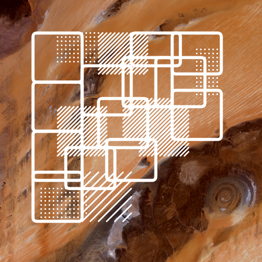
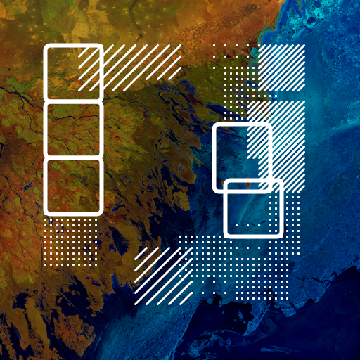
It is only after this extended process of scene compilation that the final selections are passed through to the next stage of the creative process. This involves analysing each scene using a program that scans a demarcated pixel sampling field, determining its global brightness properties (i.e. range, ratio, averages). This information is then used within another scanning loop to establish the saliency thresholds by which individual pixels are grouped into distinctive framed ‘regions’, with each corresponding to the particular brightness signatures of the image—enacting a simple instance of machine-vision. These demarcated regions cue a drawing routine that overlays a sequence of geometric grids and outlines onto the original scene, visualising the outcomes of these analytic routines, and so generating the initial half of the final diptych.
❮
❯
This sequence depicts the original source imagery before and after processing, with the second image showcasing the different geometric outlines and grid patterns overlaid. Compiled and processed by the author, using data courtesy of USGS.
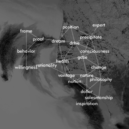
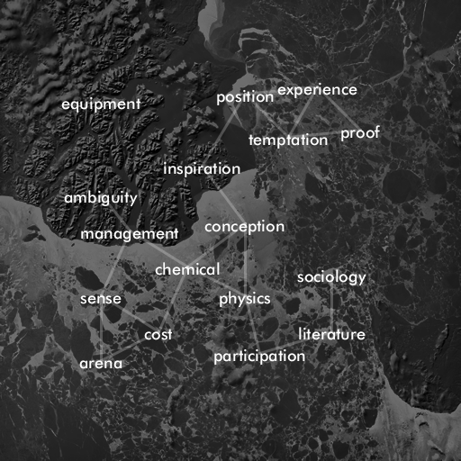
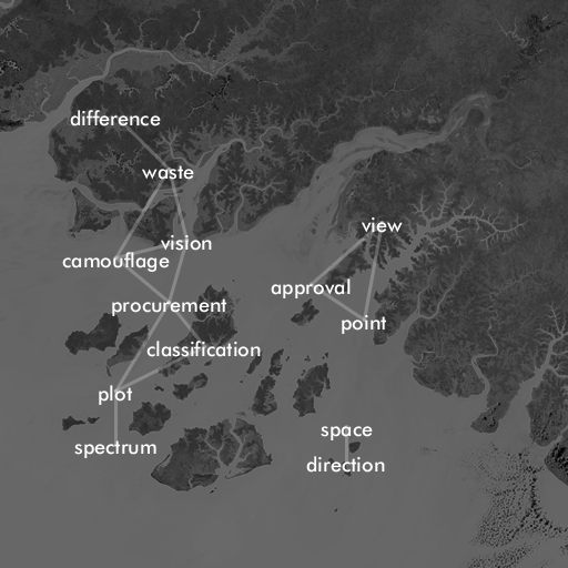
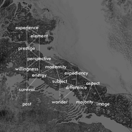
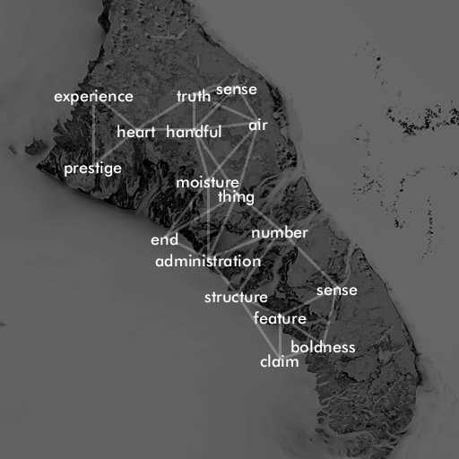
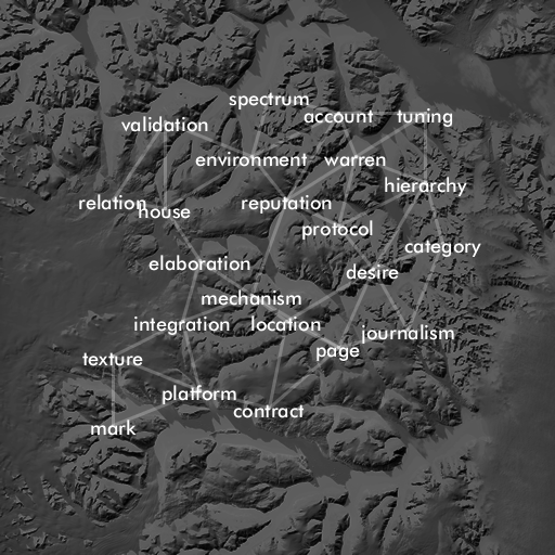
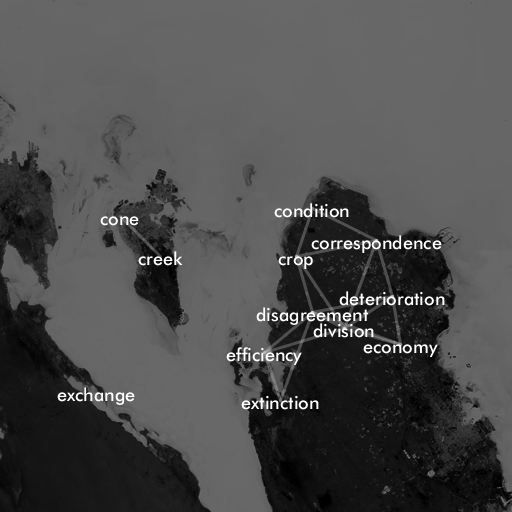
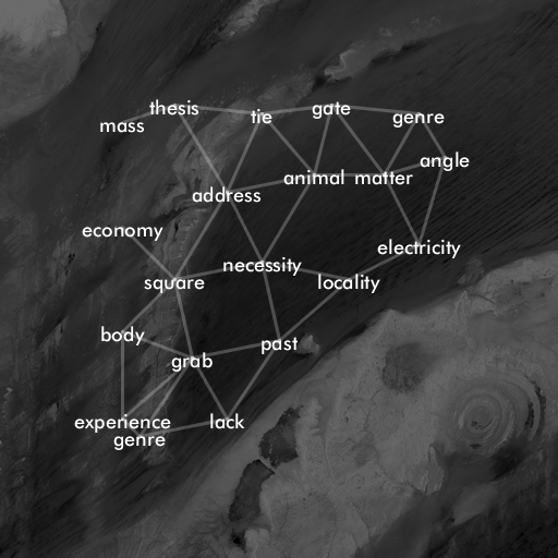
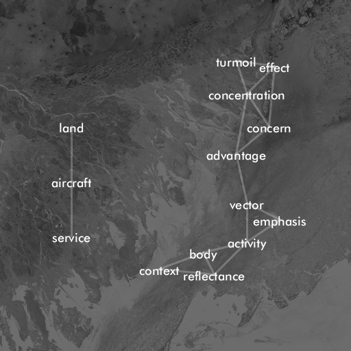
The second image in each Orbital Reveries diptych is derived from the analytic routines described above. Initially, a textual corpus is parsed by a separate algorithm that identifies and lists its constitutive proper nouns, before graphing these as a two-dimensional array that corresponds with the pixel dimensions of the source scene. To generate specific textual outputs using this array, the coordinates of the terrain brightness signatures identified in the first image are employed as lookup vectors corresponding to specific word indices. This elliptical process is easier to capture algorithmically than in prose, but it could be analogised as overlaying the analysed topography of the satellite scene, encoded as a two-dimensional matrix of values, onto the topography of the textual array, encoded as a series of lookup indices, and then observing which point values on the former intersect with those of the latter, and thus which words are selected for display. It is these words that are then overlaid onto an inverted copy of the source scene, geometrically aligned with the terrain signatures that mobilised them. A filtering routine is employed subsequently to remove overlapping word selections, so as to preserve legibility, and this is why not every apparent area of the source image has an associated word overlay. To complete the process, a web of interconnecting vectors are then drawn between the remaining words, based on their relative proximities, and so furthering the visual depiction of a novel textual topography that emerges from the terrain below.
It this final outcome that I characterise as being a ‘textscape’, both in reference to the functional and orthographic alignment of the detected terrain features and the textual structures they actualise, but also in acknowledgement of how the end result does not fit readily into conventional genre catagories—although a relationship might be discerned with sufficently accomodating conceptions of ‘visual’ poetry, and, indeed, outputs from earlier iterations of Orbital Reveries have been published as part of visual poetry anthologies and web exhbitions (Rewilding; ‘Trånslatiøns’). Genre catagories aside, the core gesture here is to create an exchange between the imaged landscapes and the languages used to frame and articulate them within different disciplinary contexts—to generate a concurrent map of the physical and discursive terrains entangled by satellite sensing. Additionally, the visual effect of the diptych format invokes also the composite structure of multispectral imagery, as emerging from the combination of seperate sensory bands—a crucial quality that can be overlooked when examining the final outputs. As will be discussed shortly, both of these aspects work together to reveal the multiplicity of technical and conceptual relations that enable the production and interpretation of satellite scenes, and so undercutting any sense of their depicting absolute, transparent captures of the world below.
The final diptychs. Note the longform ‘data stamp’ titles, which are explained further below. Compiled and processed by the author, using data courtesy of USGS.
The textual sources used by the system are drawn from an array of scholarly, non-fiction works. In the pieces compiled for this essay, the sources used are: 1) The Dictionary of Physical Geography, fourth edition, which, as the name suggests, provides an exhaustive description of the scientific and technical terminology characterising the discipline, and thus giving a rich account of its discursive structures; 2) A Vast Machine: Computer Models, Climate Data, and the Politics of Global Warming by Paul Edwards, which recounts the deep origins of contemporary, planetary scale sensing and computing infrastructures, along with their supporting practices, research disciplines, and technoscientific and geopolitical contexts; 3) “Landsat’s Role in Ecological Applications of Remote Sensing” by Warren Cohen and Samuel Goward, which provides a summary perspective on the topic; 4) “The Gendered Eye in the Sky: A Feminist Perspective on Earth Observation Satellites” by Karen Litfin, which is being cited throughout this discussion; 5) “Mutating Media Ecologies” by Jussi Parikka, which is cited also. All these works either engage directly the subject of satellite sensing, or explore and critique the greater contexts in which it operates as part of an ostensibly global perceptual and knowledge-making apparatus.
Other sources being experimented with currently include historic works that document the development of remote imaging, such as The Face of the Earth as Seen from the Air: A Study in the Application of Airplane Photography to Geography by Willis Thomas Lee (1922), and Airplane Photography by Herbert Eugene Ives (1920). Additionally, some current pieces are drawing on pioneering works of nature writing, such as The Sea Around Us by Rachel Carson (1951) and A Land by Jacquetta Hawkes (1951), as well as further contemporary works of scholarly criticism, including Gabrys’ Program Earth: Environmental Sensing Technology and the Making of a Computational Planet and chapters from Lisa Parks and James Schwoch’s edited collection Down to Earth: Satellite Technologies, Industries, and Cultures.
It should be acknowledged that during the often-lengthy process of compiling each diptych of Orbital Reveries, specific curatorial decisions concerning the satellite scenes gathered, or the textual sources employed, have only a subtle effect on the final outcomes. As might be expected, undifferentiated imagery results in relatively uniform geometrical overlays, but these remain able to generate interesting lexical sequences due to how the system treats the information they depict. Equally, the role of the textual corpus selected is less clear-cut than may be supposed, for scientific papers and technical dictionaries can generate combinations of words that are as unusual and provocative as might emerge from eco-critical texts, which themselves can produce seemingly very dry, technically inflected compositions.
A selection of additional diptychs. Compiled and processed by the author, using data courtesy of USGS.
Perhaps the most substantive impact of these curatorial decisions is found within the contexts of reception they assemble around each composition, and their resultant juxtapositions or resonances. For instance, imagery of the rampant Australian or Californian wildfires of 2020 can bear out the fearsome materialities driving the digital climate models charted within A Vast Machine. Alternatively, the stark isolation of Canadian Arctic coastlines, emphasised from an orbital vantage, may be contrasted against the lush immediacy of the imagery carried through The Sea Around Us, or be amplified by the immense scales of mineral time at work in the language of A Land. More generalised scenes can find any sense of their depicting unspoilt idyls, photographed by some passing angel, effectively troubled by the critical language of Program Earth or Down to Earth. Again, these effects are inferred mainly from an awareness of these sources, which is why each piece is entitled with a longform ‘data stamp’, which consists of the USGS product identifier of the source image (e.g. ‘LC08_L1TP_013043_20210123’), followed by the sensory band combination from which it was composed (e.g. ‘B543’), and then a title-author-date reference (e.g. ‘EYEINTHESKY_LITFIN_97’).
As evident from the above description, Orbital Reveries is characterised by enacting relatively elaborate generative routines, yielding outputs that are appreciated better as markers of the technical and conceptual structures behind their creation, as opposed to standalone artistic works. My own creative and critical motivations here can be summarised as enacting a broad gesture of resistance against the ostensive remoteness and autonomy of the satellite gaze, and, from this, any conception of the latter as holding the Earth in a state of total, multispectral information capture, eclipsing any other worthwhile possibilities of knowing the world from either above or below. Stated in more specific terms, the formatting of each diptych as a multi-part composition, emerging out of compound processes, is an attempt at evoking the networks of discourse, practice, and agency that both operate satellite infrastructures and which frame their outputs as meaningful in different contexts for different purposes—to characterise their operational contingency and partiality, as opposed to being unmediated ‘God’s eye’ outlooks onto the world. In order to elaborate further how Orbital Reveries seeks to instantiate this aspect, the remaining balance of this discussion will turn now to noting, very briefly, some of the current critical thinking around technical imaging more broadly, before illustrating how these have informed the final configuration of the project. The discussion will then close with some personal reflections on what digital sensory art may usefully bring to the table for exploring, expressing, and engaging with the uncertain, troubling futures ahead.
Critical Themes
In their editorial introduction to Down to Earth, Parks and Schwoch express how satellites ‘are enigmatic objects of study that demand methodological experimentation and creativity. Their remoteness and imperceptibility constantly beg the question: how is it possible to study and understand things and processes that cannot readily be seen or sensed (and which, in some cases, are purposefully hidden and suppressed)?’ (2) Compounding this sense of physical and critical inaccessibility are the very paradigms that led to, and are instantiated by satellite systems: namely, ocularcentric knowledge-making, machinic image generation, and the operationalisation of both for geopolitical ends.
To outline these aspects briefly, it can be noted, following Warf, that Western modernity is characterised by a focus on rendering phenomena visually prehensible. This ocular-centrism, as the privileged vector of sensing and sense-making, owes its origins in-part to the Cartesian formulation of rationalist thought, with its predication on the distinction, and ontological separation, between the ‘inner reality of the mind and the outer reality of objects’, with seeing, abstracted from all other conditions, becoming synonymous with knowing (Warf 43). This principle instantiated itself across a range of interrelated developments, such as the meridian grids imposed by European powers worldwide to facilitate the exchange networks of incipient capitalism, enclosing global space within structures of perceptual rationality and control: a colonial spatial order. Warf goes on to describe how this entangling of knowledge with ordering visual sensibilities primed the Western episteme for the subsequent conception and invention of photography, ‘light writing’, as the foremost medium through which a pre-eminently visual reality could be framed, known, represented, and then managed across space and time (45).
The potential indexicality or iconicity of photography as a means of recording and characterising the observable world has driven a major body of philosophical and critical debate since its inception, with historic and contemporary accounts all acknowledging the problematics inherent to any naïve vision of a single-authored expression of specific moments in space and time. In photography’s digital incarnation, however, a shift in these understandings has come to the fore, especially in a period of machine generated, machine analysed imagery—captured in wavelengths beyond the thresholds of the human eye, and which may never be processed or presented for viewing with such. Mackenzie and Munster encapsulate this as the ‘operationalisation’ of visuality, as carried through modes of ‘distributed invisuality’, whereby the relationships between images are what characterise their potential signification—as articulated through differential processes of imaging, recording, interpretation, and application, which are all variously enacted within distributed assemblages of human and more-than-human agency (18). Farocki, in a similar vein, characterised the proliferation of such intermediate data-forms as being ‘operative images’, in which they do not exist to represent an object beyond themselves, but contribute instead to a specific sense-making operation for a delimited purpose, and wherein human visual prehension may be neither required nor relevant (17). Azar, Cox, and Impett summarise the core effects of this situation, thus:
If this relation between seeing and knowing was once fundamental to acting in the world, the current distribution of agency across complex networks of non-human agents allows simultaneously more visibility—and, as a consequence, more knowledge about processes that before were not visible—and less knowledge about the very processes behind the way in which these new visualities are rendered visible.
As discussed earlier, one evident response to such critical aporia are the artworks by Nielson, Engelmman and Dyer, and Paglen, which seek to make visible otherwise invisible (or at least highly obscure) structures and processes. Orbital Reveries is operating in a similar register to their creative interventions, although it does not centre the hardware of satellite infrastructure to the same extent, and concerns itself rather with the algorithmic logics and discursive contexts involved in gathering, processing, and characterising the received data. Here, the diptych format allows initially for the depiction of multiple, distinctive algorithmic processes (or at least their outcomes), in which the underlying source scene functions as but only one component, as a body of values to be analysed, interpreted, and re-presented through a series of machinic operations, rather than serving as the principle locus of interest and insight. Even without knowledge of the exact means by which the final diptych is generated, its intended effect is to offer a sense of its configuration as emerging from, and gathering significance through, a distributed set of actions, a contingent assembly of structures, processes, and other operative images, rather than standing as an autonomous representational artefact. The role of the textual content especially is to further this invocation of the contexts that shape the uses and reception of Earth observation systems, but it does suggest also, however tentatively, the capacity of the latter to enter into exchanges with other modes of knowledge-making and expression that go beyond datafied visualities—to create outputs that are generative of new interpretative questions, perspectives, and outlooks, and so exploring in-turn the potentials of sensory systems in actualising the sensed world, as opposed to functioning as straightforward conduits for its ostensive delivery to human understanding.
To summarise, the diptych of gridded geometries and textual constellations is an effort at mobilising a sense of satellite imagery as an operative manifestation of multiply entangled contexts and processes, and thus taking on a multiplicity of potential forms as appropriate to varying inscriptive, infrastructural, and usage contexts—from radio downlink, database entry, compiled data-product, scientific resource, political tool, cultural trope, creative artwork, critical catalyst, and beyond. In suggesting how satellite data is rendered interpretable and significant within different epistemic contexts, the ultimate aim of Orbital Reveries is to raise questions that turn away from what these data-forms seemingly depict, and focus instead on how they are moulded into different kinds of representation, and in what contexts, and for what purposes—an enquiry that is soon followed by considerations as to what is not captured by these perceiving and interpreting assemblages: of what aspects of Earthly life and experience they fail to prehend, in their optimisation for specific use-cases, discourses, and enabling power structures. It is these questions that in-part motivated the work of Litfin and Gabrys, and inspired the latter’s enquiries concering what other possibilities of sensing and sense-making might be realised through digital systems.
Technology, Creativity, Possibility
The above account of Orbital Reveries is, evidently enough, my own characterisation of its expressive qualities, and could never stand as a definitive statement. It is no revelation to assert that the most interesting power of art lies in its capacity to speak beyond the imaginings of the artist, and so while this discussion has necessarily centred my own vectors of thought, the artistic and critical potential of Orbital Reveries is manifestly contingent on a multitude of external factors. Certainly, much of this potential is not fully realisable when it is treated as a body of autonomous art objects, becoming evident instead when assessing how it is made possible by, and given meaning through, an assemblage of different technologies, practices, and vocabularies. In other words, the end products of their intersection, the outputs yielded, do not, in themselves, tell the full story of their becoming. Consequently, they are reliant, as with all art, on the interpretive generosity of the onlooker—on the latter’s sense as to whether they form a viable catalyst for substantive thought and reflection, if not at the level of what they represent in themselves, but in terms of what their processes of creation might have to say about their subjects.
As both an artist and a researcher, the chief value I derive from my creative practice is the consciously experimental processes involved, and their bringing together of different formations, both technical and conceptual, in order to generate new lines of enquiry about how we can, and how we may yet, produce alternate modes of sensing and sense-making. That is, I pursue artistic practices as a means of formulating and expressing different stories about the world: to bear out connections between phenomena that might not be readily imagined otherwise, or to catalyse reflections on their relational significance and implications. The goal here is never to derive definitive answers, as if they are simply lying in wait, but to enable, through the uncertainties and contingencies of practice, varied potentials of worldly becoming, and to see what might be learnt in the process.
There are still caveats to observe here, of course, when it comes to how this kind of digital work is received and interpreted by more general audiences—at least in terms of what my own encounters have suggested. Many of my artistic projects are conspicuously technical in their appearance and origins, and thus Orbital Reveries, along with others, have tended to invite questions that centre on how they have been made, rather than what they might go on to represent. If these mechanisms are then dutifully explained, the artworks, and their interpretative potentials, are sometimes associated only with these elements alone—as being (yet-)another technical demonstrator of ‘AI’ artistry, with this aspect becoming the chief source of interest. This reaction has been sufficiently common that I now preface all my discussions, whether conducted in the academy or in public, with what amounts to a disclaimer: that I see the work as the result of creating ‘with’ and ‘alongside’ algorithms, and not a pretence at ‘replacing’ human creativity, howsoever understood. Nevertheless, I am still often left with a sense that the contemporary popular discourse around AI and algorithms, as nebulous entities threatening to supersede all of human agency at a stroke, can still represent a substantive barrier against the capacity of generative digital art to engage with topics beyond its immediate technocultural contexts. Given the long history and well-established cultural presence of digital and electronic art more broadly, I am surprised to be writing statements such as this, but it reflects nonetheless my consistent experiences at varied academic and public events in recent years. Certainly, such anecdotes do not sit well with decades of intensive critical reflection on what digital art represents, and so my frequently reductive encounters give additional pause for thought concerning the role of particular forums in shaping its expressive potential—that is, the issue of its ‘translation’ between different contexts of reception and understanding, and how these might be negotiated, both in governing the art produced, and the spaces in which it is encountered and reflected upon.
Related to this, I perceive there are challenges in connecting the overt technicity of digital artworks to the aspirations of ecological art more broadly. When presenting in forums concerned with the latter, a not-infrequent reaction to some of my efforts has been an implicit scepticism—a query as to whether satellite infrastructures, datalinks, database architectures, and digital algorithms could ever speak meaningfully to environmental concerns, or whether they in-fact obstruct human bodily and sensory agency for this end. Such concerns echo those noted by Litfin regarding the eco-discourse of the late 1990s, with digital infrastructure representing, however implicitly, a weapon of the enemy: the means by which the world is arrested into abstract matrices of command, control, and commerce—not dissimilar, perhaps, to how computers were sometimes perceived in the 1950s and 60s, and the issues this generated around their use for expressing artistic works. Certainly, the far greater awareness that now permeates concerning the pervasive, growing, and profoundly damaging impacts of digital technology lifecycles can only (rightfully) trouble any naïvely celebratory readings of digital art. Consequently, in trying to realise different kinds of speculative, experimental work, I remain fearful that artistic sensory practices, of the kind being extolled here, risk being discarded as frivolous, technocentric experiments while the world burns. The digital certainly has enough media coverage, enough societal privilege, and is often critical to processes that are ruining the planet for often fruitless, violent, or distressing ends. Surely, then, the need is to reduce its presence, especially when it comes to ecological matterings, rather than centre it further?
There is no easy response to this critique, being predicated on substantively different goals and assumptions from those that have motivated my work. Such divergent attitudes are an issue that Litfin also acknowledged in her reflections over two decades ago, concerning the minor political utility of satellite infrastructure (41). If an answer had to be forwarded here, I would venture once more that the chief benefit of such endeavours is not necessarily realised in their creative outcomes, but in the processes undertaken—testing the experimental approaches that, I would suggest cautiously, shall likely become ever more necessary when coping with the radically severe challenges ahead. On a pragmatic note, such efforts ensure that certain technical devices and architectures are not simply abandoned to those who benefit the most in possessing hegemony over their usage, and the necessary knowledges concerning—which is perhaps the one aspect shared by all the art projects cited throughout this discussion. The goal here might not be necessarily to either revolutionise or somehow redeem these systems, or indeed to produce art that is deemed all that ‘good’, but instead to keep the spirit of play and experimentation alive in the teeth of contexts, processes, and technologies that might otherwise seek to preclude them, and so resist the cycles of cynicism and despair that justifies, or merely upholds, a destructive, predominant a-priori.
It might be instructive here to follow climate scientist Kate Marvel, and perceive courage as the resolve to do well without the assurance of a good ending. When it comes to viewing the concrete function of sensory art, amidst profound ecological crises, then depicting it as another vector of material resistance, working alongside many others, can help characterise the ultimate scope of its potential, while also impeding the crass rhetorics of ‘transformation’ and ‘disruption’ that so readily underlies popular digital discourse. Stated more boldly, if current digital infrastructures are too materially extensive, corporately embedded, and technically sclerotic to ever truly mitigate their myriad ecological impacts, then it remains worth examining how they may yet assist other such efforts, and not leave them only to the designs of tech evangelists, crypto speculators, commercial enterprises, or military actors. In so doing, this work can help facilitate a more generative set of discussions, even when acknowledging their own barriers and limitations. That is, in the processes of confronting and grappling with the immense difficulties at hand, however minor or provisional the outcomes, such work can provide another vector away from outlining yet-another dolorous assessment of the future, or fruitless remonstration of varied human failings, and instead help in capturing the potentials for surprise, and the kinds of empathy and humility it facilitates, that may yet be realised within always more-than-human environments.
Cohen, Warren, Samuel Goward. “Landsat’s Role in Ecological Applications of Remote Sensing.” BioScience,vol. 54, no. 6, 2004, pp. 535-545, https://www.fs.usda.gov/treesearch/pubs/27146. Accessed 1 July 2021.
Engelmann, Sasha, and Sophie Dyer. “About.” Open Weather Community, https://open-weather.community/. Accessed 21 April 2021.
Ezell, Linda Neuman. “Table 4-161. Chronology of Landsat Development and Operations.” Nasa Historical Data Book: Volume III, Programs and Projects 1969-1978, 15 Oct. 2010, https://history.nasa.gov/SP-4012/vol3/table4.161.htm. Accessed 21 April 2021.
Mack, Pamela. “LANDSAT and the Rise of Earth Resources Monitoring.” From Engineering Science to Big Science, Jan. 2000, https://history.nasa.gov/SP-4219/Chapter10.html. Accessed 21 April 2021.
Mackenzie, Adrian, and Anna Munster. “Platform Seeing: Image Ensembles and their Invisualities.” Theory, Culture, and Society, vol. 36, no. 5, 2019, pp. 3-22, 10.1177/0263276419847508. Accessed 21 April 2021.
Parks, Lisa, and James Schwoch. “Introduction.” Down to Earth: Satellite Technologies, Industries, and Cultures, edited by Lisa Parks and James Schwoch, Rutgers University Press, 2012, pp. 1-16. JSTOR, https://www.jstor.org/stable/j.ctt5hjdg3.4. Accessed 21 April 2021.
Warf, Barney. “Dethroning the View from Above: Toward a Critical Social Analysis of Satellite Ocularcentrism.” Down to Earth: Satellite Technologies, Industries, and Cultures, edited by Lisa Parks and James Schwoch, Rutgers University Press, 2012, pp. 42-60. JSTOR, https://www.jstor.org/stable/j.ctt5hjdg3.6. Accessed 21 April 2021.
Willis, Thomas. The Face of the Earth as Seen from the Air: A Study in the Application of Airplane Photography to Geography. American Geographical Society, 1922. Project Gutenberg, http://www.gutenberg.org/ebooks/62068. Accessed 21 April 2021.