I wish to begin by acknowledging an absence, and thereby evoking a presence. This essay expands on writing, thinking, talking, and walking undertaken in collaboration with London-based writer Mary Paterson. Throughout our collaboration Mary has asked questions about place, migration, identity, and belonging. Questions that are mostly unanswerable. Questions that I’ve tried to answer anyway. Because speaking about the unspeakable with someone comes as a relief.
In July 2017 Mary and I co-authored a call and response poem called “Which Way is West?” We developed this poem into a keynote in two voices for On the Inhabitability of Cartographic Worlds, hosted by Université Paris 8 in Paris in December 2017. I have since adapted this keynote for Transient Topographies: Space and Interface in Digital Literature and Art, hosted by the Moore Institute for Research in the Humanities and Social Studies at the National University of Ireland, Galway, in April 2018, and The Machine in Anglophone Arts and Literature at the Sorbonne in Paris in April 2019.
I bring these references to presentation contexts which might otherwise be relegated to a footnote into the body of the text here to highlight the impossibility of singularity. Even in absence, our voices are entwined with other voices, other places, other texts.

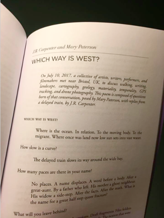
J. R. Carpenter & Mary Paterson (2018) "Which Way is West?" PRISIM International 56.2
A keynote is supposed to establish an underlying theme for a conference. My life’s work has been to disrupt established orders, to refuse totalising principles, to create open-ended structures. And yet, a talk is necessarily linear, moving relentlessly forward through time. Echoing the timeline feature common to animation, audio, and video editing software, this essay is designed to be read in a long horizontal scroll. Building on a series of keynotes, this essay is structured around keyframes. A term borrowed from animation, a keyframe is a position in time designed to define the illusion of movement from one image to another.
When I say ‘image’ I refer both to visual images and to thought-images, or Denkbild. Gerhard Richter describes the Denkbild as a philosophical miniature, “a poetic form of condensed, epigrammatic writing [encoded] in textual snapshots…” (2007, 2).
To be clear, I’m applying this critical frame retroactively. I’ve only begun reading about Denkbild recently. I’ve been writing them most of my life.
When I say ‘I’, I don’t always mean me. Sometimes my ‘I’ is fictional. Sometimes I wish to refer to a subject position bordering on the plural, which is not quite we. For the past ten years it has been the official policy of the United kingdom to create a 'hostile environment' for migrants. I am a migrant. A double-emigrant born of immigrants born of emigrants.
I was born in Nova Scotia, near Port Royal, site of the oldest permanent European settlement in North America north of St Augustine, Florida. Port Royal was established by Samuel de Champlain in 1605. The New World was founded in the national territory of Mi'kma'ki, which had already been inhabited by the native Mi'kmaq for at least 13,000 years. I am a child of settlers. So even where I come from, I come from away.
In England, my white skin and excellent grasp of the English language has masked the complexity of my immigration status. Mary Paterson asks: What is a privilege? And I reply: Not having to ask this question. Not being asked this question. Not answering this question. Not questioning.
I wish to use my privilege to speak. Not for, but from amongst.
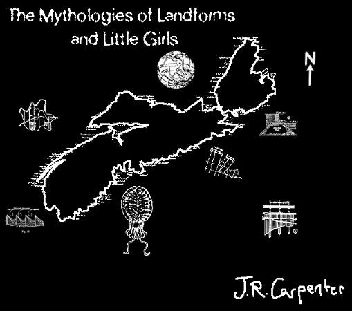
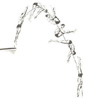
J. R. Carpenter (1996) Mythologies of Landforms and Little Girls luckysoap.com/mythologies
Questions of place and displacement have long pervaded my work. Maps figure prominently, operating often simultaneously as images, interfaces, and place-holders for pasts which could never be mine.
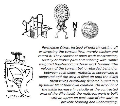
In Mythologies of Landforms and Little Girls (1996), a map of Nova Scotia is surrounded by diagrams from geology and engineering textbooks. The deadpan technical descriptions of dikes, groins, and mattress work add sexual overtones to an otherwise relatively chaste first-person feminine narrative of pre-pubescent longing.
This text was published twice in print journals, but I remained unsatisfied with the fixed structure of the narrative enforced by the page. I wanted to convey a moment of realisation, wherein a number of ideas come together at once. It mattered little what order the ideas came in, only that they came together in the end. In 1996 I marked up the print pages to create an HTML version of the work in which readers could move through the story in any way they wished. This new mode of reading was facilitated by a cartographic interface informed by the paper placemats found in many tourist restaurants in Nova Scotia. A body of land is reduced to the barest outline of a coastline surrounded by icons indicating sites of purported interest.
J. R. Carpenter (1996) Mythologies of Landforms and Little Girls luckysoap.com/mythologies
In Deleuze and Language, Jean-Jacques Lecercle suggests that, contrary to the practice of linguistics, which aims to “clip the wings of language to keep it still and make it manageable for dissection” (2002: 71), the practice of cartography “treats language as a plane, of immanence and of consistency; it respects the heterogeneity and diversity of language, it does not freeze its currents of becoming into structures, it does not force its lines of flight into a hierarchy of channels” (71).
The cartographic interface of Mythologies of Landforms & Little Girls allows new narrative structures to emerge through the creation of an entrespace – an in-between space wherein the dialects of the absurd and the inarticulate, the erotic and the scientific, desire and loss, and image and text may finally co-exist.
The cartographic interface of Mythologies of Landforms & Little Girls allows new narrative structures to emerge through the creation of an entrespace – an in-between space wherein the dialects of the absurd and the inarticulate, the erotic and the scientific, desire and loss, and image and text may finally co-exist.
J. R. Carpenter (2005) The Cape
luckysoap.com/thecape
luckysoap.com/thecape
In Mythologies, geological metaphors of deep time are employed to relegate the awkwardness of childhood to a yet more distant past, a sub-strata of distant memory. Taking up the geologically-inflected Deleuzian notion that strata are acts of capture operating by coding and territorialization, the past can be understood as a territory. Both settler colonialism and migration create striated territories in which, within a single geographical location, many conflicting versions of past events must coexist.
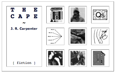
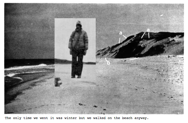
In The Cape (2005) another first-person female child narrator describes a visit to see her grandmother Carpenter on Cape Cod. In lieu of family photographs, the work is illustrated with maps and diagrams from the Environmental Geologic Guide to Cape Cod National Seashore, published in 1979. A geological map (right) splits the story along a time/place axis. The family has travelled to a distant place, but also, to a time that the child narrator cannot inhabit. The front page (left) asserts [ albeit parenthetically ] that this is a work of fiction. The credits page insists that although this child shares my name she cannot possibly be me. My authorial voice is enunciated through an operation of coding, an act of capture. My HTML code makes this language of loss manageable for dissection without freezing its currents of becoming. The scientific, diagrammatic, and cartographic techniques employed by the Geological Guide provide a ready-made vocabulary for the narrator, whose voice might not otherwise not be believed.
In The Cape (2005) another first-person female child narrator describes a visit to see her grandmother Carpenter on Cape Cod. In lieu of family photographs, the work is illustrated with maps and diagrams from the Environmental Geologic Guide to Cape Cod National Seashore, published in 1979. A geological map (right) splits the story along a time/place axis. The family has travelled to a distant place, but also, to a time that the child narrator cannot inhabit. The front page (left) asserts [ albeit parenthetically ] that this is a work of fiction. The credits page insists that although this child shares my name she cannot possibly be me. My authorial voice is enunciated through an operation of coding, an act of capture. My HTML code makes this language of loss manageable for dissection without freezing its currents of becoming. The scientific, diagrammatic, and cartographic techniques employed by the Geological Guide provide a ready-made vocabulary for the narrator, whose voice might not otherwise not be believed.
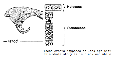
J. R. Carpenter (2005) The Cape
luckysoap.com/thecape
luckysoap.com/thecape
The first-person female child narrator is a voice born of displacement, disarticulation, and fracture. The prose in The Cape is at once sparse and ponderous: "It was winter but we walked on the beach anyway." “These events happened so long ago that this whole story is in black and white.”
As Richter observes of the Denkbild, this is a literature which “self-consciously exposes the inescapable contamination of the theoretical by the figurative” (2007, 25). Here too in this essay, I’m calling attention to the source code which pre-figures the text on the screen. Further, I'm overtly mixing practice and theory rather than, quoting from Richter again “glossing over this tension in an effort to create the false semblance of disembodied meaning” (25).
As Richter observes of the Denkbild, this is a literature which “self-consciously exposes the inescapable contamination of the theoretical by the figurative” (2007, 25). Here too in this essay, I’m calling attention to the source code which pre-figures the text on the screen. Further, I'm overtly mixing practice and theory rather than, quoting from Richter again “glossing over this tension in an effort to create the false semblance of disembodied meaning” (25).
J. R. Carpenter (2005) The Cape luckysoap.com/thecape
In Writing and Difference, Jacques Derrida observes: “[s]ite, this land, calling to us from beyond memory, is always elsewhere” (1978: 66). Similarly, in Sea and Fog, Etel Adnan asks: “What does it mean to belong to a land? For those of us who live away from our private history, the question never heals” (2012: 74).
Mary Paterson asks me: How many paces are there in your name? And I mishear her. I miss here. No, places. A name displaces. A word before a body. After a great-aunt. By a father who left. His mother a ghost neighbour. His widow a side-step. After the facts. After the math. What is the name for a great half step queer fracture?
Mary Paterson asks me: How many paces are there in your name? And I mishear her. I miss here. No, places. A name displaces. A word before a body. After a great-aunt. By a father who left. His mother a ghost neighbour. His widow a side-step. After the facts. After the math. What is the name for a great half step queer fracture?
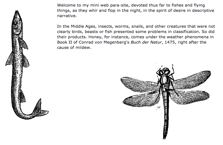
J. R. Carpenter (1995) Fishes & Flying Things luckysoap.com/butterflies/parasite.html
I began using the internet as a medium for the creation and dissemination of dispersed non-linear narratives in 1993. I made my first web-based work in 1995. Many of my web-based works may be read as web ‘sites’ of longing for belonging, for home.
Home for me is an unanswerable question, a land that is always elsewhere, always already lost. Richter identifies “an abiding emphasis on loss” (2007: 34) as a defining characteristic of Denkbild. But, he observes, this sense of loss then becomes “the site on which dialectical thought unfolds” (36). My early adoption of the internet as a medium was due in part to my attraction to the web as an in-between space wherein the dialectics of desire and loss, image and text, map and trace, place and space could finally co-exist.
Home for me is an unanswerable question, a land that is always elsewhere, always already lost. Richter identifies “an abiding emphasis on loss” (2007: 34) as a defining characteristic of Denkbild. But, he observes, this sense of loss then becomes “the site on which dialectical thought unfolds” (36). My early adoption of the internet as a medium was due in part to my attraction to the web as an in-between space wherein the dialectics of desire and loss, image and text, map and trace, place and space could finally co-exist.
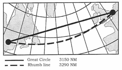
Great Circle Line. Public domain.
Thus far I’ve used the term ‘map’ loosely. All maps are born of specific times and of places, of systems of thought and of measurement, of policies of trade and of governance. Gerhard Mercator’s famous conformal world map of 1569 is oft critiqued as Eurocentric because it depicts northern regions as disproportionately large in relation to equatorial regions. In Medium, Messenger, Transmission, Sybille Krämer reminds us that Mercator’s map is not simply a projection of a world view. It’s also a visual representation of a mathematical construct which allows sailors to sail in straight lines over a curved ocean (2015: 196). The Mercator projection underlies nautical and aeronautical navigation to this day. In performing this equation, the map becomes a mediator between a user and a territory.
Krämer observes that cartography underwent a profound reformation in the seventeenth and eighteenth centuries: “map producers abandoned the elaborate and fantastic projections created in their studios and exchanged them for fieldwork in a landscape whose topology was exactly quantifiable” (2015: 188). This anodyne summation belies an underlying violence. Samuel de Champlain, the ‘Father of New France’ was above all a cartographer. His ‘fieldwork’ was funded by the fur trade which was fuelled by Northern Europe’s insatiable desire for fur-lined collars and broad-brimmed hats of finest beaver felt.
Through the operations of measurement and direct observation, map-making was transformed during the so-called ‘Age of Discovery’ from an art to a science. The quantifiable new world was written over the surface of a topography which had already been inscribed by its inhabitants through thousands of years of use. The map became a metaphor, a symbolic representation of a terrain that it strove to approximate exactly.
Through the operations of measurement and direct observation, map-making was transformed during the so-called ‘Age of Discovery’ from an art to a science. The quantifiable new world was written over the surface of a topography which had already been inscribed by its inhabitants through thousands of years of use. The map became a metaphor, a symbolic representation of a terrain that it strove to approximate exactly.
J. R. Carpenter (2011) The Broadside of a Yarn luckysoap.com/broadside
My work aims to disrupt this assumptive relation. My maps are impossible. They wilfully confuse and confound boundaries between physical and digital, truth and fiction, home and away. They do this not through obscuration but rather through exaggeration.
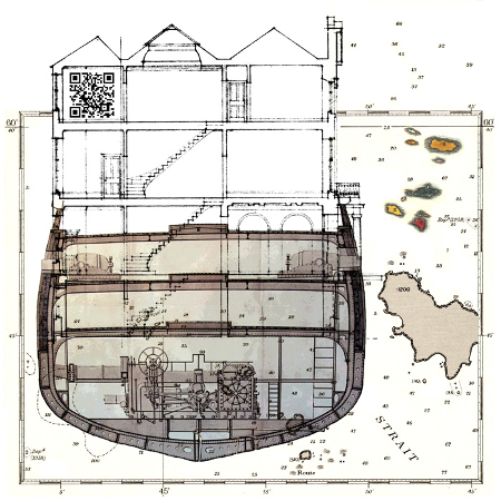
In this detail The Broadside of a Yarn (2012) (left), a ship shape looms, larger than islands. Above decks, stairs instead of sails. A house wreck, adrift in a transient topography. Ocean depths over-spilling a cartographic boundary.
In this detail The Broadside of a Yarn (2012) (left), a ship shape looms, larger than islands. Above decks, stairs instead of sails. A house wreck, adrift in a transient topography. Ocean depths over-spilling a cartographic boundary.
In “Mapping’s Intelligent Agents,” Shannon Mattern stresses that “we need to keep asking critical questions about how machines conceptualize and operationalize space. How do they render our world measurable, navigable, usable, conservable?” (2017). I agree that we need to ask these questions forward, of machines of surveillance, of the GPS tracking devices we carry in our pockets, and of the Google Street view cameras freeze-framing pedestrians as they drive by, paving the way, as it were, for a world navigable by self-driving cars. But we also need to keep asking these questions backwards, applying this critical frame to earlier navigational regimes.
The steam engine rendered our once vast world measurable in hours rather than weeks, forcing a reconceptualization of the temporal trajectories of elemental media. J. M. W. Turner’s oil painting “Rain, Steam and Speed – The Great Western Railway,” completed in 1844, shows a machine engulfed in a cloud of its own making, an intermingling of coal-fired steam and air-born pollution.
The steam engine rendered our once vast world measurable in hours rather than weeks, forcing a reconceptualization of the temporal trajectories of elemental media. J. M. W. Turner’s oil painting “Rain, Steam and Speed – The Great Western Railway,” completed in 1844, shows a machine engulfed in a cloud of its own making, an intermingling of coal-fired steam and air-born pollution.
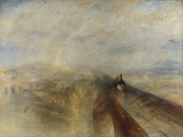
J. M. W. Turner (1844) Rain, Steam and Speed – The Great Western Railway, National Gallery, London (public domain)
In 1990 I moved from Nova Scotia to Montreal by sleeper-train. Seventeen years later I used the then nascent Google Maps API to chart the qualities of sleep in each of the eight neighbourhoods that I’d lived in to create Les huit quartiers du sommeil (2007).
Due to changes to the Google Maps API, the words "For development purposes only" now appear in a repeating pattern across the embedded satellite view of the city, highlighting the dialectic between the poetic and corporate use of digital space.
The Prologue presents what Benjamin terms a “dialectical image” (Richter 2007: 61) wilfully confusing distance and proximity, waking and sleeping, leaving and arriving, here and there. It does this by fusing past and present navigational regimes within a paradoxically transient topography. Passengers operating in human time aboard a train operating in machine time move through a landscape operating in geological time. All are captured in a textual image which must freeze time in order to become legible:
The night train tunnels termite-determined through silent miles of bark-black forest.
Passengers forage for provisions, restless-long this expedition; minds race ahead,
pace coach and sleeping class compartments listing along the fleuve Saint-Laurent,
dip-slice-glide-lurch-swaying, steady-forward, slow as the Voyageurs' paddles.
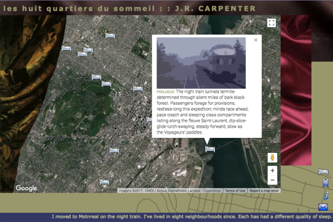
J. R. Carpenter (2007) Les huit quartiers du sommeil luckysoap.com/huitquartiers
From the 1680s until the late 1870s, the word ‘voyageurs’ referred to the French Canadian men who transported furs by canoe through extensive river networks which had been navigated by native populations for thousands of years before they were charted by Samuel de Champlain. The cartographic reformation re-conceptualised these rivers as networks of power and commerce. The appropriation of the native technology of the canoe and the commodification of the bodies of both the native animals and the migrant voyageurs radically re-operationalized these native spaces.
From 1928-1998 a Canadian intercity bus company called Voyageur Colonial Bus Lines covered roughly the same territory as the voyageurs fur traders.
Today, the tourism industry invites us to pay for the commodification of our own labour. One adventure vacation website states: Imagine what it was like to be a part of the Fur Trade as you and a team of fellow paddlers ply the very waters used by the fabled Voyageurs on their journeys to and from the rich fur grounds to the West.
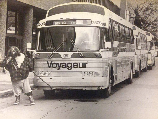
The Great Antonio, noted Canadian wrestler and strongman, pulls four Voyageur buses filled with passengers in Montréal in 1960.
(Source: Library and Archives Canada)
(Source: Library and Archives Canada)
In 2006 I was commissioned by Oboro, an artist-run-Centre in Montréal, to create a new web-based work for the 50th anniversary of the Conseil des Arts de Montréal. Entre Ville (2006) mapped the in-between spaces of the back alleyways of the Mile End neighbourhood of Montréal.
Kramer observes: “When the map is employed as a medium… something outside of the map is altered through the act of orientating oneself with the map” (2015: 207). Writing about my neighbours made me aware that I was writing from amongst them. In the months following the launch of Entre Ville, many of my long-time neighbours were forced out of their rented apartments by gentrification. The streets became haunted with their stories. Our stories. Faced with imminent eviction I began to write as if I was no longer there, about a neighbourhood that was no longer there.
Kramer observes: “When the map is employed as a medium… something outside of the map is altered through the act of orientating oneself with the map” (2015: 207). Writing about my neighbours made me aware that I was writing from amongst them. In the months following the launch of Entre Ville, many of my long-time neighbours were forced out of their rented apartments by gentrification. The streets became haunted with their stories. Our stories. Faced with imminent eviction I began to write as if I was no longer there, about a neighbourhood that was no longer there.
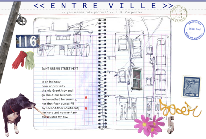
J. R. Carpenter (2006) Entre Ville luckysoap.com/entreville
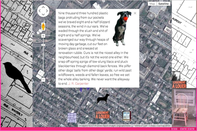
In 2008 I was commissioned to create a new web-based by Dare-Dare, an artist-run-centre in Montréal which operated out of a shipping container in a park with no name at the edge of the Mile End neighbourhood.
in absentia (2008) used the Google Maps API to map the sudden disappearances of neighbours (fictional or otherwise) from the places (real or imagined) where they once lived. Sharing in what Richter identifies as Benjamin’s “fundamental methodological interest in the appearance of things in the moment they are about to disappear” (2007: 61), this work asked a number of unanswerable questions akin to those posed years later by Mary Paterson throughout our collaboration:
What stories do we leave behind when we leave a place?
What stories spring from absence?
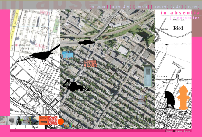
J. R. Carpenter (2008) in absentia luckysoap.com/inabsentia
In Wanderlust: A History of Walking, Rebecca Solnit argues, “the walking body can be traced in the places it has made; paths, parks, and sidewalks are traces of the acting out of imagination and desire… Walking shares with making and working that crucial element of engagement of the body and the mind with the world, of knowing the world through the body and the body through the world (2000: 29). In A Thousand Plateaus, Deleuze and Guattari famously implore: “Make a map, not a tracing” (2007: 12). They claim that “What distinguishes the map from the tracing is that [the map] is entirely oriented toward an experimentation in contact with the real” (12). But cannot a trace also be similarly engaged, as Solnit suggests, in “knowing the world through the body”? Krämer further troubles this distinction: “The map can only become an object of critical analysis when it is not at the same time deployed to facilitate movements in disorientating spaces” (2015: 191). In other words, once the map is no longer used for practical purposes, it appears as a trace.
J. R. Carpenter (2008) in absentia luckysoap.com/inabsentia
In both Entre Ville and in absentia, the map and the trace co-exist in an uneasy proximity. The walking body can be traced in the stories it has left behind. Clicking on the dog in the lower left corner of Entre Ville causes a new text to appear: Sniffing For Stories. The neighbourhood as it once was can be traced in both works in old maps, no longer used for practical purposes. The Google Maps satellite view in in absentia offers every appearance of being “in contact with the real” but when is real? Since the launch of the work in 2008 the satellite images have been updated. Changes to the Google Maps API have rendered a view of the neighbourhood which was once freely accessible for use in digital poetry illegible without the surrender of a credit card number. A new fiction has been written over the surface of the once well-known.
J. R. Carpenter (2006) Entre Ville (detail) luckysoap.com/entreville
Writing in 1984, Michel de Certeau categorised pedestrians as “walkers… whose bodies follow the thicks and thins of an urban ‘text’ they write without being able to read...” (1984: 93). Cartography has since undergone a second profound reformation. Krämer observes: “digitalization transforms mapping into a cultural technique for movement in landscapes of knowledge” (2015: 206).
Walking in 2018, our GPS-enabled phones track our movements through physical spaces as well as through landscapes of knowledge, of data, of desire (Collins 2017). We write into the Ur text of Google Maps. In each new app update we read what our bodies have written.
Krämer states: “Maps — fundamentally — make the invisible visible” (2015: 200). I’m not entirely sure I agree. Maps may also make it more possible to see less. Head down against the rain, hand shading the screen against the sun, walking in a strange city, we follow the blue dot.
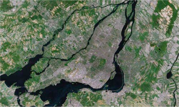
The island of Montreal, in the St Laurence River, Quebec (Source: Google Maps)
For nineteen years I lived in English as a minority language on the French-speaking island of Montreal.
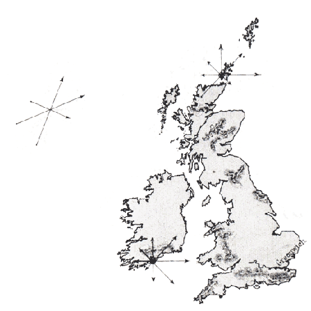
In 2009 I moved to the island of Great Britain, where my English will forever mark me as a foreigner. In Elizabeth Bishop’s late great poem “Crusoe in England,” Crusoe bemoans his rescue: “Now I live here, another island, / that doesn’t seem like one, but who decides?” (1971: 48).
In 2009 I moved to the island of Great Britain, where my English will forever mark me as a foreigner. In Elizabeth Bishop’s late great poem “Crusoe in England,” Crusoe bemoans his rescue: “Now I live here, another island, / that doesn’t seem like one, but who decides?” (1971: 48).
J. R. Carpenter (2013) ...and by islands I mean paragraphs luckysoap.com/andbyislands
In Canada, I come from the East Coast. In England, I lived for a long time in the West Country. In Nova Scotia, the sun rises over the Atlantic. And so, when Mary Paterson asks: Which way is west? I reply with more questions: Where is the ocean. In relation. To the moving body. To the migrant. Where once was land now low sun sets. When will sun setting not rising setting over vast water start to feel normal?
In 1605 Samuel de Champlain founded Port Royal at the mouth of the Bay of Fundy, on the East coast of Canada. The Bay of Fundy is home to the highest tides in the world.
In 2017 Mary and I met on the Southern banks of the Severn Estuary, on the West coast of England. The Severn Estuary is home to the second highest tides in the world.
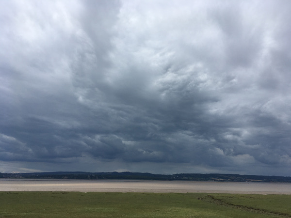
J. R. Carpenter (2017) Severn Estuary, UK
We had been invited there by Bristol-based artist Lizzie Phelps to participate in her interdisciplinary research project "GPS Embroidery," exploring walking, writing, landscape, cartography, geology, materiality, temporality, and drone photography. Carrying GPS tracking devices we walked long looping letterforms along the banks of the Severn, tracing / leaving / writing / making / mapping words in our wake.
I walk-wrote a line from my hybrid print and web-based work The Gathering Cloud (2016-2017):
We walk on the bed of the sea of the air.
I walk-wrote a line from my hybrid print and web-based work The Gathering Cloud (2016-2017):
We walk on the bed of the sea of the air.
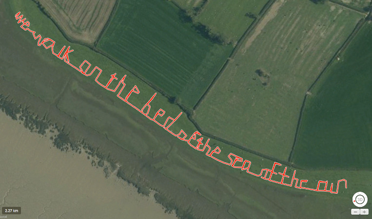
GPS Embroidery (2017) Severn Estuary, UK
Mary asks: What is traceable from above?
I don’t know the answer.
Where does above start? With the wind blowing above the ocean’s currents flowing above Tectonic plates floating above liquid magma encircling the Earth’s molten core? With our planet’s orbit around the sun? With the sun’s slow arc in a dark galaxy still unfolding its incomprehensibly ancient wings?
Here this essay pivots on a spatial axis. Although we will continue to read horizontally, as if we are crawling along the Earth’s surface, for the remainder of this essay I want to think about verticality, about heights and depths unattainable for humans without technology. A sheer drop, from cloud top to ocean floor.
In 2016 I was commissioned to create a new web-based work for the NEoN Digital Arts Festival in Dundee, Scotland. The theme was “The Spaces We’re In.” Of this theme the festival's curators, Sarah Cook and Donna Holford-Lovell, write: “Physical urban space and virtual information space are inseparably intertwined. How does being digital change our sense of our spatial surroundings?”
When the curators first approached me I was in the midst of moving house. Surrounded by boxes of books, papers, photographs, floppy discs, hard drives, and tangles of miscellaneous cables, I knew immediately that I wanted to try to call attention to the physicality of so-called ‘cloud’ storage.
I’d written on the complex relations between biological and digital memory in earlier work, but the scale of the digital cloud seemed too vast to think about in terms of the human body.
I knew I had to think bigger. I turned to the clouds in the sky.
Anonymous - Camille Flammarion, L'Atmosphère: Météorologie Populaire (Paris, 1888), pp. 163. Public Domain.
For most of human history the heavens have served as a source of legitimacy, providing meaning and orientation. The sky as compass, calendar, map, and clock.
Aristotle observed: Clouds sweeping along with great noise close to the earth strike fear into those that see them as portents of some greater catastrophe. In the long interval between Aristotle and the Enlightenment clouds were generally thought too changeable to be scientifically quantifiable.
In 1802, an amateur meteorologist named Luke Howard put forward a new methodological nomenclature. In contrast to fixed Linnaean taxonomies, Howard’s deceptively simple classificatory system allowed for continual movement. The Latin names he outlined remain in use today.
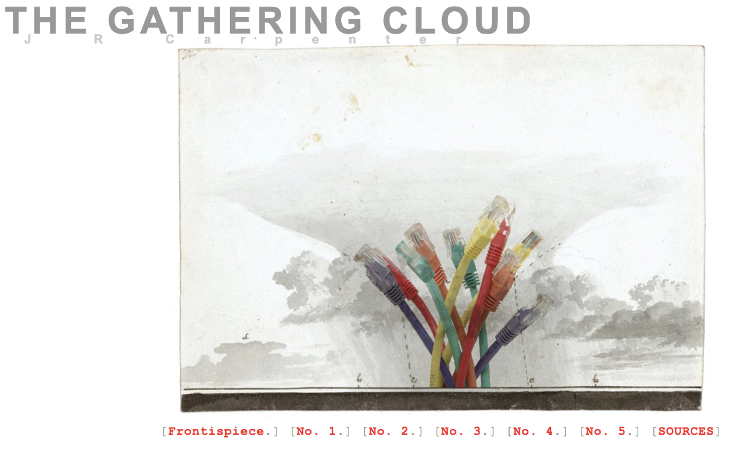
J. R. Carpenter (2016) The Gathering Cloud luckysoap.com/thegatheringcloud
My web-based work The Gathering Cloud (2016) combines fragments of text from Howard’s essay On the Modifications of Clouds (1803) with phrases from recent writing on media theory and the environment.
These are pared down into hypertextual hendecasyllabic verses situated within animated gif collages composed of illustrations from Howard’s essay and images appropriated from publicly accessible cloud storage services.
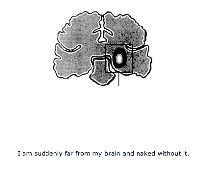
The Cloud is an airily deceptive name, connotating a floating world far removed from the physical realities of data. Data centres worldwide use thirty billion watts of electricity annually. If all the data centres constituted a country of their own it would be the fifth most power-hungry country in the world.
These are pared down into hypertextual hendecasyllabic verses situated within animated gif collages composed of illustrations from Howard’s essay and images appropriated from publicly accessible cloud storage services.
The Cloud is an airily deceptive name, connotating a floating world far removed from the physical realities of data. Data centres worldwide use thirty billion watts of electricity annually. If all the data centres constituted a country of their own it would be the fifth most power-hungry country in the world.
J. R. Carpenter (2016) The Gathering Cloud luckysoap.com/thegatheringcloud
The cognitive dissonance between the cultural fantasy of the ephemerality of cloud storage and the hard facts of its environmental impact is bridged, in part, through the constant evocation of animals. The fog comes on cute pics of little cat feet. A cloud the weight of one hundred elephants. A USB fish.
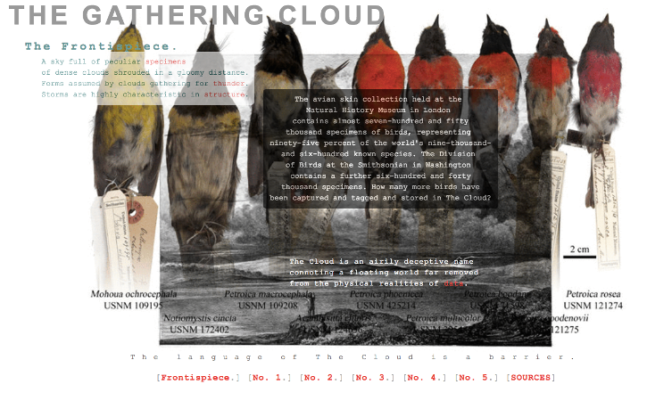
The Frontispiece, as Howard so vividly writes in his description of illustrations, shows:
A sky full of peculiar specimens of dense clouds shrouded in a gloomy distance.
The avian skin collection held at the Natural History Museum in London contains almost seven-hundred and fifty thousand specimens of birds. How many more have been captured, tagged and stored in The Cloud?
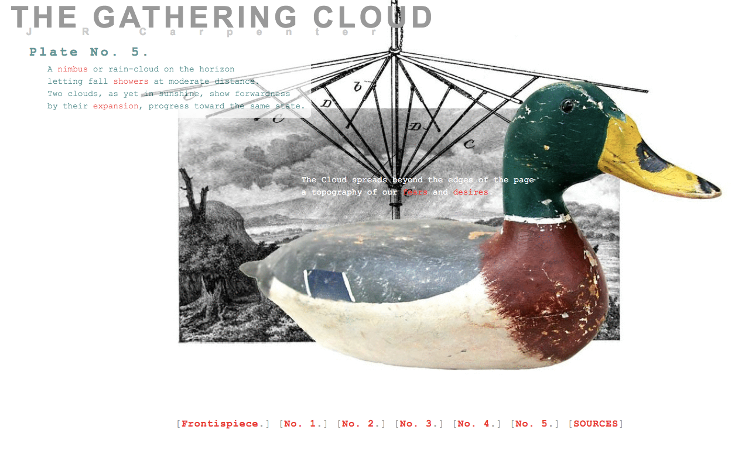
J. R. Carpenter (2016) The Gathering Cloud luckysoap.com/thegatheringcloud
The Gathering Cloud launched with a performance at a Pecha Kucha Night held in Dundee on the 8th of November 2016, the night of the US elections. I hadn’t intended for the title to sound quite so ominous. In light of recent events, now more than ever we need to find ways to talk about the enormity of climate change in human terms we can understand and act upon.
A small print iteration of The Gathering Cloud colour printed on A3-sized paper and shared through gift, trade, mail art, and small press economies further confuses the scant boundaries between animal and mineral, physical and digital, scarcity and waste.
A small print iteration of The Gathering Cloud colour printed on A3-sized paper and shared through gift, trade, mail art, and small press economies further confuses the scant boundaries between animal and mineral, physical and digital, scarcity and waste.

J. R. Carpenter (2017)
The Gathering Cloud. Axminster: Uniformbooks
The Gathering Cloud. Axminster: Uniformbooks
In May 2017 a print book iteration of The Gathering Cloud was published by Uniformbooks, featuring an extended essay on the cloud written in hendecasyllabic verse. In his foreword, media theorist Jussi Parikka describes the multi-modality of The Gathering Cloud project as “a series of material transformations made visible through a media history executed as digital collage and print publication, hendecasyllabic verse, and critical essay”.
In her afterword, poet Lisa Robertson describes this iterative compositional process another way: “...whatever gathers things together whatever gathers people together and thinking together given the great long whooshing passage of time wind economies technologies believes and whatever gathers a sentence together and whatever a poem is both physical and mysterious and so we wish to read...”
In her afterword, poet Lisa Robertson describes this iterative compositional process another way: “...whatever gathers things together whatever gathers people together and thinking together given the great long whooshing passage of time wind economies technologies believes and whatever gathers a sentence together and whatever a poem is both physical and mysterious and so we wish to read...”
The Cloud spreads beyond the edges of the page a topography of our fears and desires. Like a muzzled creature, the cloud strains to be more than it is, its sights on larger quarry. We treat the air as an abode of the endless, an infinite receptacle for pollution. No wonder The data Cloud is the premier receptacle for backup dumps, archaic, obsolete data. Both waste and vastness derive from the Latin vastus—desolate, but also expansive. For much of human history we have perceived of the ocean depths in much the same way.
In an article published in The Guardian during the search for the missing Malaysian Airlines flight MH370, Philip Hoare observes: “Until 1773, when Constantine John Phipps… began to sound the ocean bed, many people thought the sea was bottomless… During his voyage towards the north pole in search of the fabled north-west passage... Phipps employed a lead weighted line to measure the distance between himself and the bottom of the ancient sea between Iceland and Norway. That strand of hemp linked the Enlightenment with the pre-history of the earth… for a century this northern nadir remained the profoundest known ocean” (2014).
Barbara Bridger & J. R. Carpenter (2015) Notes Very Necessary luckysoap.com/notesverynecessary
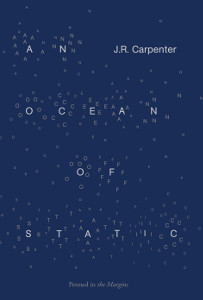
J. R. Carpenter (2018) An Ocean of Static. London: Penned in the Margins
From the late 15th century onwards, a flurry of voyages were made into the North Atlantic in search of fish, furs, the fabled Northwest Passage, and beyond into the territories purely imaginary. Today, this vast expanse is crisscrossed with ocean and wind currents, submarine cables and wireless signals, seabirds and passengers, static and cargo ships.
The above text is from the back cover of my poetry collection An Ocean of Static. published by Penned in the Margins in 2018. The title is a four-word Denkbild, a conflation of deep ocean and an etheric realm non-human noise. I have little else to say about this book because everything I’ve already written in this essay has had the kernel of this book in it. I offer instead a few of the unanswerable questions which prompted it's writing:
When does leaving end and arriving begin?
When does an emigrant become an immigrant?
What happens between sending and receiving, between call and response?
On 25 September 1791, Rear Admiral Bruni d’Entrecasteaux departed from Brest, France, in search of the lost Lapérouse. Fittingly, one of his two 500-ton frigates was named La Recherche. On board was a young hydrographer called Charles-François Beautemps-Beaupré (1766-1854).
In 2018 I was commissioned by the « Mondes, interfaces et environnements à l’ère du numérique » research group at the Université Paris 8 to create a new web-based work in partnership with the Archives Nationales.
The Pleasure of the Coast: A Hydro-graphic Novel (2019) aims to disrupt western cartography’s assumptive relation between the symbolic and the real.
J. R. Carpenter (2019) The Pleasure of the Coast luckysoap.com/pleasurecoast
The Pleasure of the Coast is an imperfectly bilingual work, composed of a corpus of fragments. The title and much of the text is détourned from Roland Barthes’ The Pleasure of the Text (1973). Technical writing and coastal elevations made in the South Pacific by Beautemps-Beaupré (1791-1793) intermingle with excerpts from Suzanne and the Pacific (1921), a symbolist novel by Jean Giraudoux written in direct opposition to the mechanistic view of science based on the assumption of an objective reality. This triple-language system unfolds in long horizontally scrolling web pages, mimicking the coast as it slips past the ship. The ship, La Recherche, is the machinic mediator for this fiction. The ship is a metaphor, in the ancient Greek sense, a vehicle moving between places across spaces, linking “spatial trajectories” (de Certeau 115).
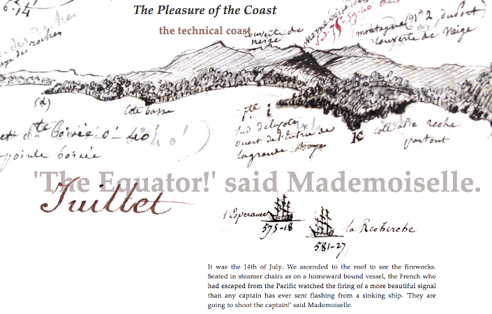
J. R. Carpenter (2019) The Pleasure of the Coast luckysoap.com/pleasurecoast
Lest we appear to have slipped back into a horizontal line of inquiry, consider that Beautemps-Beaupré lived in a world driven by wind. Wind was the invisible force powering colonial expansion. Data collected by wind-powered sailing ships during this period continues to inform our daily thoughts and actions. Consider the weather app on your mobile phone, for example. Historical weather data recorded in Admiralty ships’ logs under the direction of Beaufort contributes to the accuracy of weather forecasting.
Beautemps-Beaupré was a close contemporary of the Irish-born British Admiralty Hydrographer Francis Beaufort (1774-1857). Although best known in his time as a hydrographer, posthumously Beaufort is most commonly associated with the scale named after him, for measuring the force of the wind.
Beautemps-Beaupré was a close contemporary of the Irish-born British Admiralty Hydrographer Francis Beaufort (1774-1857). Although best known in his time as a hydrographer, posthumously Beaufort is most commonly associated with the scale named after him, for measuring the force of the wind.
The Beaufort Scale informs the poetic structure of This is a Picture of Wind: A Weather Poem for Phones, a web-app commissioned by the IOTA Institute in Canada in 2018. A sea chart of the waters off the coast of South West of England underlies a calendrical rather than longitudinal grid. Numbers denoting ocean depths intermingle with the words of a part fixed, part variable poem composed of three type of textual data: fragments culled from a vast corpus of English science and nature writing, prose poems composed through sustained quotidian observation of a specific landscape, and couplets randomly generated in part by live wind data and in part by the inexorable passage of time.
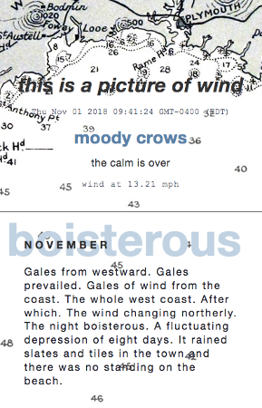
J. R. Carpenter (2018) This is a Picture of Wind luckysoap.com/apictureofwind
In "Dynamic Poetics: J.R. Carpenter’s This is a Picture of Wind," Johanna Drucker observes that the language in this work is not metaphorical, but rather, it "grapples with the actual, addressing the difficulty of bringing sensing and knowing together. [...] The grid arbitrarily marks our days and months off from each other. [...] The wind rushes through the rational structure, even as it leaves behind [...] a residue of poetic notes, observations formulated in relation to fleeting sensations of the volatile atmosphere" (2018: 22).
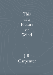
J. R. Carpenter (2020) This is a Picture of Wind. Sheffield: Longbarrow Press
At the time of this writing (April 2020), this work contains two years of wind. One is based on barometric observations recorded by Luke Howard at his home Tottenham in the early nineteenth century. The other, on my own quotidian observations posted to the @TheRiverDart Twitter account from my home in the early twenty-first century. A print book iteration of This is a Picture of Wind forthcoming from Longbarrow Press in May 2020 will introduce a third year of wind, based on Vita Sackville-West’s journalistic writing about the garden at Sissinghurst, her home in the early twentieth-century. This new year of wind will be added to the digital work over the course of 2020. In this way, the digital work remains an open-ended structure able to change in response to the ongoing forces of wind, air pressure, and plants in flower.
Mary asks: What are you waiting for? And I reply with a line lifted from earlier work. What? Why not? I have borrowed from so many other writers, artists, and scientists over the years. So many other voices, maps, books, bodies, and territories.
When I say "I" I mean this cacophonous polyphonic asynchronous not-quite we: we readers, we writers, we walkers, we migrants, we sailers, we settlers. We sketch the clouds and note the ocean depths. We take a map, we leave a trace. So what are we waiting for?
Something recognisable. Something familiar, to hold against so much newness. A sense. Of belonging. Of home. Quiet. An open-ended structure. Within which to...
THANKS:
This essay has taken a long and circuitous route to arrive at this form. Thanks to Mary Paterson for asking unanswerable questions. Thanks to Shazia Hafiz Ramji for publishing our long strange poem. Thanks to the conference organisers who trusted me to deliver unconventional keynotes: Anne Karhio at NUI Galway, Arnaud Regnauld at Université Paris 8, and Omayyah Al-Shabab, Anouk Bottero, and Diane Drouin at the Sorbonne. Thanks to Will Luers for inviting me to adapt this mass of material for publication. And thanks to all the authors who have fed this thinking. But a few are cited here.
This essay has taken a long and circuitous route to arrive at this form. Thanks to Mary Paterson for asking unanswerable questions. Thanks to Shazia Hafiz Ramji for publishing our long strange poem. Thanks to the conference organisers who trusted me to deliver unconventional keynotes: Anne Karhio at NUI Galway, Arnaud Regnauld at Université Paris 8, and Omayyah Al-Shabab, Anouk Bottero, and Diane Drouin at the Sorbonne. Thanks to Will Luers for inviting me to adapt this mass of material for publication. And thanks to all the authors who have fed this thinking. But a few are cited here.
WORKS CITED:
Etel Adnan (2012) Sea and Fog. NY: Nightboat Books
Elizabeth Bishop (1971) “Crusoe in England,” The New Yorker, November 6, 1971
J. R. Carpenter & Mary Paterson (2017) “Which Way is West?” PRISM International 56.2.
Michel de Certeau (1984) The Practice of Everyday Life. trans. S. Rendall. Berkeley, LA, London: U California Press
Keith Collins (2017) Google collects Android users’ locations even when location services are disabled, Quartz. 21 November 2017
Gilles Deleuze & Félix Guattari (2007) A Thousand Plateaus: Capitalism and Schizophrenia. Minneapolis: U Minnesota Press
Jacques Derrida (1978) Writing and Difference. trans. A. Bass, Chicago: U Chicago Press
Johanna Drucker (2018) Dynamic Poetics: J.R. Carpenter’s This is a Picture of Wind, IOTA:DATA, Iota Institute
Philip Hoare (2014) MH370: the forlorn bleeps remind us of the vast depth of the ocean, The Guardian, 8 April 2014
Sybille Krämer (2015) Medium, Messenger, Transmission: An Approach to Media Philosophy. Amsterdam U Press
Jean-Jacques Lecercle (2002) Deleuze and Language. Basingstoke & NY: Macmillian
Shannon Mattern (2017) Mapping’s Intelligent Agents, Places Journal, September 2017
Lizzie Philps (2016-2018) GPS Embroidery, Bristol, UK
Gerhard Richter (2007) Thought-Images: Frankfurt School Writers’ Reflections from Damaged Life. Stanford U Press
Rebecca Solnit (2000) Wanderlust: A History of Walking. NY: Penguin